
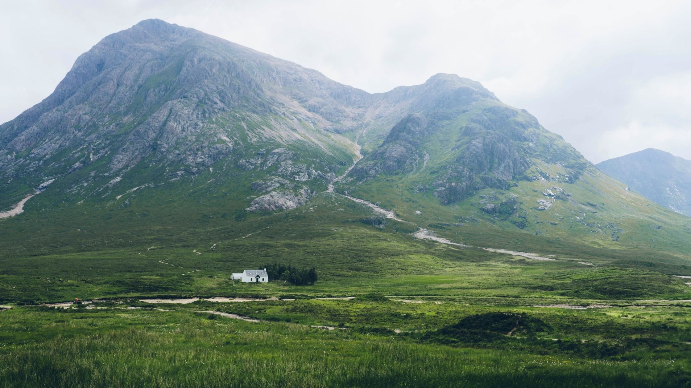
scottish mountain walks glencoe

5 Scottish Mountain Walks That Are A Hikers Dream

If you’re looking for an amazing hike, look no further than Scotland. With its towering mountains and stunning landscapes, Scotland is a hiker’s paradise.

Scotland is a stunning country famously known for its highlands, lochs, and mountains. In fact, Scotland is home to over 3,000 miles of coastline and some of the tallest mountains in Europe.

But don’t be intimidated, there are walks, hikes and climbs to suit everyone, from trekking newbies to hardened hill walkers.

Here we have detailed five Scottish mountain walks that are a hiker’s dream.

scottish-mountain-walks

These five amazing Scottish mountain walks should be on your list – not only because they offer a challenge for those who want one, but also because they reward hikers with incredible views from peaks or through valleys that few people ever get to see up close…

1. Ben Nevis

We couldn’t make a list of the top treks in Scotland without including Ben Nevis which one of the three mountains climbed during the National 3 Peaks 24 Challenge

Ben Nevis in Fort William is the King of the Munros, standing at 1,345 metres (4412 feet), and is the highest point in the United Kingdom, standing 36 metres higher than the well-known Ben Macdui (which is on the edge of the Cairngorm plateau and is the highest point in the Cairngorms National Park).

While the ‘Tourist Route’ up Ben Nevis is still an excellent way to see the mountain, the route up Ben Nevis via the knife-edge Carn Mor Dearg Arête, also known as the CMD Arête, is perhaps the most intriguing. You’ll also ascend the Munro of Carn Mor Dearg if you take this route, and the ridge walk itself must be one of the most beautiful in the UK, if not the world — a suitable way to summit Scotland’s highest mountain. You’ll need a little nerve and be comfortable with heights!

Ben Nevis has fantastic views from its peak, which are well worth the climb to get there! It is an extremely challenging hike, but it’s a journey that every serious hiker should attempt at least once in their lifetime. Attempt it on a clear day, you may be lucky enough to see as far as the Isle of Arran and even the coast of Northern Ireland.

Ben Nevis Hike – Key information

ℹ️ Difficulty Level: The climb up the mountain is made up of rocky terrain and scree, so be prepared for a challenging hike. 

🕒 Time Taken: Around 3 hours in total

📍 Route Information: There are many routes to the summit of Ben Nevis, but the popular tourist route starts at the car park at Torlundy, just off the A82 road. You can find Ordnance Survey route information for Ben Nevis here, including distance, elevation and key waypoints.

2. The Cobbler (Ben Arthur)

The Cobbler isn’t quite a Munro at 920 metres, but it’s proof that if you only climb Munros, you’ll miss out on some of Scotland’s top treks. This walk, also known as Ben Arthur, is located in the Arrochar Alps.

It’s a one-hour 45-minute journey from Edinburgh or one-hour drive from Glasgow from the Succoth car park in Arrochar. The journey begins with a zigzagging trail with views back across Loch Long before going three kilometres to the foot of the mountain to begin the ascent.

The triple-headed peak, Munro or not, has one of the most striking forms of any Scottish mountain. It’s also one of the more rewarding summits, with some spectacular vistas (and photo opportunities) at the top. Not least if, after “threading the needle” on the north summit, you scramble up the rocky tower at the top.

The views from the summit are breathtaking, and you can see as far as the Isle of Arran and The Cobbler’s two other neighbouring peaks: Ben Lomond and Ben Vorlich.

The Cobbler is a great hike for those who don’t take exercise lightly, and it’s one that should definitely be on your list of mountain walks in Scotland!

The Cobbler (Ben Arthur) Hike – Key information

ℹ️ Difficulty Level: The Cobbler is an amazing mountain walk for hikers of all levels.

🕒 Time Taken: The walk to the summit takes around 3-4 hours, and it’s about 9 miles long.

📍 Route Information: The most popular route to the summit is from the car park at Inveruglas, on the west side of Loch Lomond.

You can find Ordnance Survey route information for Ben Arthur here, including distance, elevation and key waypoints.

scottish mountain walks arrochar alps

3. Loch Ossian Munros

If you’re looking for a beautiful hike in Scotland, look no further than Loch Ossian Munros. Located near the town of Corrour, in the Highlands of Scotland, Loch Ossian Munros is a cluster of mountains that offer hikers an incredible challenge and some of the most amazing views in Scotland. 

It’s a challenging hike, but the views from the summit are well worth it. You can see as far as the Isle of Skye and the Outer Hebrides on a clear day.

The best way to access Loch Ossian Munros is by starting at the Corrour railway station and walking west. There are no roads leading to the trailhead, so the only way to access it is either by train or by foot.

The hike will take you up, down, and around steep hills, as well as across rivers and rock faces. It’s a challenging hike but one that’s worth every step.

Loch Ossain Munros Hike – Key information

ℹ️ Difficulty Level: Extremely challenging, not for beginners.

🕒 Time Taken: Total time is around 10 hours give or take, covering around 15 miles!

📍 Route Information: You can find Ordnance Survey route information for the Loch Ossian Munros here including distance, elevation and key waypoints.

4. Beinn Eighe

Beinn Eighe is a mountain located in the Northwest Highlands of Scotland. The mountain is situated at the core of the Torridon Hills and is one of the most sought after mountains to climb in Scotland.

Beinn Eighe is one of the famous Munro’s (over 3000 feet high). The mountain has two main ridges, called the Coire Fionn and the Coire na Banachdich. The mountain is also well known for its wildlife, including golden eagles, red deer, and ptarmigan

Beinn Eighe is not a mountain for the inexperienced hiker, and anyone interested in climbing the Munros should consult more specialised mountain guides for information on the many paths and possibilities.

A path from a car park on the north side of the road through Glen Torridon, near the southern exit from the valley between Beinn Eighe and Liathach, is the second option to enjoy Beinn Eighe’s beauty without having to climb it all.

A path leads all the way around the back of Liathach from here. At the west end of Beinn Eighe, another trail splits off and leads around the end of Sail Mor, the mountain’s most westerly offshoot.

Beinn Eighe Hike – Key information

ℹ️ Difficulty Level: Not for beginners.

🕒 Time Taken: 3 hours.

📍 Route Information: You can find Ordnance Survey route information for Beinn Eighe here including distance, elevation and key waypoints.

5. Aonach Eagach

The Aonach Eagach is the UK mainland’s narrowest ridge path, located in the notably beautiful Glen Coe. It’s also one of the more difficult of the country’s 282 Munros to “bag”.

This is a treacherous climb with many steep, slippery, and often slick slopes and rocks. It’s not a job for the inexperienced, and it’s not one to take on alone or in bad weather. Nonetheless, it is one of the most stunning mountain climbs and experienced scramblers will be rewarded with a thrilling scramble and panoramic views of the other Glen Coe peaks, part of the Mamores ridge and is one of Scotland’s most popular and challenging hikes.

The hike to the summit of Aonach Eagach can be started from two different locations: the village of Glencoe or the village of Kinlochleven. The climb up is steep and rocky, so be prepared to climb over stones and rocks. The views from the summit are well worth it, though!

Aonach Eagache Hike – Key information

ℹ️ Difficulty Level: An extremely challenging hike, and it’s not for beginners.

🕒 Time Taken: The hike from Glencoe to the summit is approximately 9 miles long, and it takes around 6-8 hours to complete. The hike from Kinlochleven to the summit is approximately 11 miles long, and it takes around 8-10 hours to complete.

📍 Route information: You can find Ordnance Survey route information for Aonach Eagach here including distance, elevation and key waypoints.

scottish mountain walks glencoe

So, if you’re a hiker who loves to explore the great outdoors, then Scotland is definitely a place that should be on your radar.

We’ve highlighted just five of the most popular Scottish mountain walks, each one offers something unique for hikers of all skill levels and walking Scotland’s trails is an amazing way to discover the great outdoors, whether you’re a local or a guest from further afield, given its small area, a hiking holiday in Scotland can be filled with soul-stirring magnificence.

Book a Guided Expedition with Mountaineerin

When you book with Mountaineerin you’re not just booking someone to walk up and down a mountain with. You are booking years of experience and knowledge of how to get the most of the environment, stay safe whilst there, look after it and most of all enjoy it!

Our guides are all fully qualified mountain leaders with an extensive understanding of the UK mountains. With comprehensive knowledge of the National 3 Peaks, Welsh 3000’s and Yorkshire 3 Peaks, our leaders are perfectly equipped to support and lead groups embarking on a mountain challenge.

For bespoke group, corporate or charity treks make a group booking enquiry

Happy Trekking!

Simon

Simon Ogunlana | Founder

A Guide To Climbing Scafell Pike

Contents

Scafell Pike Guided Treks from Wasdale Head (April - Oct)

Why book a guided Scafell Pike trek with Mountaineerin?

We guide over 800 people along this route every year!

When you book with Mountaineerin you’re not just booking someone to walk up and down a mountain with. You are booking years of experience and knowledge of how to get the most of the environment, stay safe whilst there, look after it and most of all enjoy it! 

For a private group or charity event please contact us.

Scafell Pike is the smallest of the National Three Peaks, but this doesn’t make it an easy climb.

Scafell Pike, standing at 978 metres, is the highest mountain in England. It is also a war memorial cared for by the National Trust, which makes it an irresistible climb, attracting climbers and sightseers from all over the country.

Scafell Pike is set in beautiful scenery with access to the incredible Lake District, and this provides a fantastic mid-mountain trek for the three peaks challenge.

Located in Lake District National Park, Scafell Pike is the smallest of the National Three Peaks, but this shouldn’t make you underestimate the climb. Instead, you should plan and gather as much information as possible if you want to enjoy the experience.

7 Interesting Facts about Scafell Pike

Apart from Scafell Pike being the tallest mountain in England, there are other interesting facts about the mountain that every climber should know. Here are 7 interesting facts about Scafell Pike:

  1. Scafell Pike is the highest mountain in England. It is 978 meters (3,209 feet) high and is located in the Lake District National Park.
  2. Scafell Pike is part of the Three Peaks Challenge. This is a challenge to climb the highest mountains in England, Scotland, and Wales (Scafell Pike, Ben Nevis, and Snowdon) within 24 hours.
  3. Scafell Pike is home to the highest standing water in England. Broad Crag Tarn is located at 820 meters (2,690 feet) above sea level.
  4. Scafell Pike was donated to the National Trust in 1919. This was done in honor of the men of the Lake District who lost their lives in the First World War.
  5. Scafell Pike is a popular destination for hikers and climbers. It is estimated that over 100,000 people attempt to climb Scafell Pike each year.
  6. Scafell Pike has been featured in a number of films and TV shows. This includes the films “Harry Potter and the Deathly Hallows: Part 2” and “The Secret Garden,” and the TV shows “Coronation Street” and “Emmerdale.”
  7. There are a number of different routes up Scafell Pike. There are about five routes to Scafell Pike.

Key Facts about Scafell Pike

  • Height: 978 m or 3,209 ft
  • Routes: There are five routes to choose from; Wasdale Head (the most popular and shortest), Dungeon Ghyll in Great Langdale, Corridor route via Wasdale, Boot in Eskdale or Seathwaite in Borrowdale
  • Difficulty: Smallest of the National 3 Peaks
Views of Scafell Pike across the lake in the distance

Scafell Pike Walking Routes

Like we said earlier, there are five main routes to Scafell Pike. Each of the routes starts from different sides of the mountain, and you should know all your options before climbing.

The routes are:

  1. Wasdale Head
  2. Seathwaite, Borrowdale (Corridor Route)
  3. Great Langdale
  4. Hardknott Eskdale
  5. Corridor Route via Wasdale

There are so many things to consider when choosing a route to follow. Do you want the fastest route to the peak? Or are you more of an adventurer who is more interested in details? Ask these questions and many more before making your decision.

Here’s an idea of each of the routes, so you have a clue what you’re signing up for.

Distance: 4.2km Ascent: 910 km. Time: Approx. 3 hours

The Wasdale route is the most popular route and is the usual three peaks route to the peak.

The starting point for Scafell Pike when taking the Wasdale route is the Wasdale National Trust Car Park. This is the ideal location to start climbing Scafell Pike. The car park is next to a campsite with a hot food/drinks trailer, information booth and toilets.

The Wasdale route has a very steep start, and a few rest stops might be needed when climbing Scafell Pike. Even though it’s a tourist option, this route is pretty rough and becomes indistinct halfway up. The final ascent could also be tricky in most. Rocky and stony, the terrain up Scafell is challenging, and in particular, the Wasdale route is a steep one.

This may be a small peak with many narrow and steep paths, but it is indeed mighty, making it the tourists’ choice.

Distance: 7.27km Ascent: 876m. Time: Approx. 3 – 3.5 hours

The Seathwaite is also known as the corridor route. It is one of the most impressive routes in Lake Districts and is usually on the top of every climber’s bucket list. This is an alternative route to the usual Wasdale route. ,

Unlike the Wasdale route, Seathwaite is a more accessible location to get to and is close to the beautiful town of Keswick. It also comes with some perks, such as free parking and higher quality paths to follow. Its gradients are relatively easy, and it claims to have one of the best sceneries in the Lake District.

Distance: 9.3km Ascent: 1026m. Time: Approx. 4 hours

This is a longer route to take to Scafell Pike. If you’re an adventurer and you’d love to experience more out of the climb, then this route might be for you. You have the Old Dungeon Ghyll Hotel at route start. Through this route, you’d experience lofty views into several of Lake District’s most famous valleys and impressive rock scenery.

There should be sufficient parking space in Great Langdale using the National Trust car part at Stickle Ghyll or the National Park’s Langdale car park.

Distance: 17.3km Ascent: 966m. Time: Approx. 6 hours

This is the wilder and quieter option among all routes. You will find The Woolpack Inn if you choose to climb using this route. It is a lesser-known route compared to Wasdale and the others. If you want to avoid the crowds you’d find in the Wasdale Head route during the summer times, then this route might be for you.

Distance: 7.7km Ascent: 967m. Time: Approx. 3 – 4 hours

If you decide to climb through this route, some facilities you’d find are; the Pub in Wasdale Head and the campsite at Wastwater.

Although climbers would usually start the corridor walk from Seathwaite, it can also be done from Wasdale Head. It’s not as steep as the Wasdale route, but it’s the longer and more technical option. The walk starts from Wasdale Head at the National Trust Car park, so there’s ample space to park your car.

Scafell Pike Route Map – Wasdale Route

The Wasdale route is the most popular route and is the usual three peaks route to the peak.

What is the best time of year to climb Scafell Pike?

Timing matters a lot when it comes to climbing Scafell Pike if you plan to make the best out of your experience. You need to pick a time when the mountain will be snow-free and when there will be fewer rainfalls and high winds.

May to October

As with any walk-in Britain, the best conditions will be between May and October. Although the summer offers the warmest temperatures and potential for low cloud and rain, it is also the most popular.

Getting the timing right for the trek will ultimately help make it more enjoyable; it is generally best to avoid July and August as the school holidays will most certainly mean crowds and a less authentic experience.

Early May to Late June

A weekday during late May/early June or the middle of September will give you plenty of parking options and space on the mountain. Ascending with no one in front of you will be much more scenic than trudging in someone else’s wake.

October to May

It is not unusual to find snow high up on the mountain from October through to May. Whenever temperatures are sub-zero, water ice can form, and winter equipment should be carried.

An advice is to prepare for low temperatures.
Whenever you climb, remember that the summit temperature is likely to be between five and 10 degrees lower than the valley temperature. The summit plateau can experience severe windchill at any time of year.

Climbing Scafell Pike at sunrise

Mountain Weather Scafell Pike

It is essential that you check the weather forecast before attempting to climb any mountain, including Scafell Pike.

It is impossible to predict the weather more than a couple of days in advance and even then, the weather can change suddenly in the mountains.

Attempting Scafell Pike during the summer months is likely to be the best time for weather, although strong winds, severe windchill and even snow are possible year-round.

It is not unusual to find snow high up on the mountain from October through to May.

The temperature can be 5 – 10 degrees lower at the summit of Scafell Pike than at the bottom of the valley, so it’s important to be prepared for all weather conditions.

When the temperature reaches zub-zero, ice can form and you will need winter walking equipment such as crampons.

If you are ill-equipped for these conditions, you should be prepared to turn around and abandon the climb to ensure your safety.

You can check the Met Office Mountain weather forecast for up to date information.

WASDALE HEAD WEATHER

Frequently Asked Questions

Yes a beginner can climb Scafell Pike but it is advised that you go with a guide who knows the route. The climb is tough and should not be underestimated.

It is hard to predict the weather and it is possible to experience strong winds, severe windchill, and even snow at any time of the year.

If you choose to climb the mountain on your own, ensure:

  • That you have an OS map and you know how to navigate (don’t rely on GPS alone). In a emergency mountain rescue will ask for a grid reference of your location
  • That you are prepared with the correct clothing, footwear, first aid kit, food and water
  • That you have checked the mountain weather forecast before setting off
  • That someone knows where you are going, when you are expected back and has details of your route. Don’t forget to let them know when you are back down safely!

Join a professionally guided trek

Don’t fancy going it alone?

No matter what route you take, the climb is challenging and needs adequate planning and preparation. A good number of climbers successfully get to the peak without any help. Those unlucky few – who may not have prepared adequately – fail and need to be rescued.

Join a professionally guided trek

Don’t fancy going it alone?

How long it will take you to climb Scafell Pike depends on the route you choose to take. The fastest and shortest route is the Wasdale route. It also depends on how fast you climb and what the weather conditions are like.

Join a professionally guided trek

Don’t fancy going it alone?

Yes it is possible to climb Scafell Pike in a day. The length of time it takes will depend on which route you take, how fast you walk, how many times you stop for a break and the weather conditions. It usually takes around 3-4 hours to summit and return along the Wasdale route.

Join a professionally guided trek

Don’t fancy going it alone?

The most popular route up Scafell Pike is the Wasdale route. It is the shortest and most direct route, but also the steepest.

Join a professionally guided trek

Don’t fancy going it alone?

Yes! Mountaineerin provide guided day walks up Scafell Pike along the Wasdale Route. The guided treks run between April and October. You can book here. 

We also organise bespoke treks for private groups or charity fundraising treks on a date that suits you. Please get in touch to enquire.

Join a professionally guided trek

Don’t fancy going it alone?

Join a professionally guided trek

Don’t fancy going it alone?

Wild camping in the Lake District is accepted as long as you are within recognised guidelines. Read about the guidelines here on the National Trust website.

Join a professionally guided trek

Don’t fancy going it alone?

Join a professionally guided trek

Don’t fancy going it alone?

The postcode for Scafell Pike

  • via the Wasdale route (the most popular route) from Wasdale Head is CA20 1EX
  • along the Corridor Route from Wasdale is CA20 1EX
  • via the Seathwaite route from Borrowdale (the Corridor route) is CA12 5XJ
  • from Langdale is LA22 9JY

Join a professionally guided trek

Don’t fancy going it alone?

  • Take a whistle and a head torch with you which can be used to attract attention and signal for help – you will get tired very easily by shouting
  • To alert other walkers that you are in need of help you can blow six blasts at regular intervals on your whistle, or if it is dark, six flashes on your torch
  • In a real emergency, you can dial 999 and ask for the police first and then Mountain rescue. You will need to know the grid reference of your location, the number of people in the party and the nature of the incident

Join a professionally guided trek

Don’t fancy going it alone?

We recommend wearing sturdy walking boots with ankle support. You will need to dress appropriately for the weather conditions. It is also important to bring plenty of water and snacks. You may also want to bring walking poles, especially if you are climbing the Wasdale route.

Join a professionally guided trek

Don’t fancy going it alone?

Book a private trek or charity event

Mountaineerin provide professional, guided expeditions tailored to your needs. It doesn’t matter if it’s a small group of friends or a fundraiser for a worthy cause.

Tell us a bit about your group and what date you have in mind and I will get back to you as soon as possible to discuss your guided trek! ENQUIRE TODAY

Best wishes,

Simon

Simon Ogunlana, Founder & Director

Take on the 3 Peaks Challenge!

Mountaineerin run organised National 3 Peaks Challenge events running between April and October each year.

Our qualified and first aid trained UK mountain leaders will guide you as you climb each mountain, guaranteeing a safe, fun and fulfilling climb to each summit.

Alternatively, why not consider the Yorkshire 3 Peaks Challenge?

Happy Trekking!

Simon

Simon Ogunlana, Founder & Director

A Guide To Climbing Ben Nevis

Ben Nevis is often chosen by many hikers as the starting point for the National Three Peaks challenge.

It is the largest peak out of the three and attempting the climb with fresh legs is recommended! Certainly when tackling the mighty ‘Ben’ it is useful to know what you might be encountering. We hope to equip you with some useful info.

Key Facts

  • Height: 1,345 m or 4,413 ft
  • Difficulty: The hardest climb of the National 3 Peaks
  • Time: 7-9 hours along the Mountain Track
  • The Nevis Landscape Partnership: A  community organisation who help maintain and care for the natural and cultural heritage and wild land areas of Ben Nevis. Could you make a small donation?

Getting to Ben Nevis

Stay in Fort William overnight so you can arrive ready for your hike early and rested –  with a wealth of accommodation in beautiful countryside you will be spoilt for choice!

From the 5 star Inverlochy Castle Hotel, to the local Premier Inn and an array of campsites, including Ben Nevis Holiday Park where you can pitch a tent or glamp it up in a lodge, there is accommodation to suit all pockets and preferences.

When you arrive at Ben Nevis, it is easiest to park at the Visitor Centre where at the time of writing, parking is £3 for cars and £10 for minibuses and coaches.

The postcode for the car park and visitor centre is PH33 6ST.

Ben Nevis Route Map

The starting point for Ben Nevis is the Visitors Centre where you can receive up to date information on the conditions at the summit of Ben Nevis.

The route used to climb Ben Nevis during the 3 Peaks Challenge is the Mountain Track which is popularly known as the ‘Pony Track’. This is the best route for summiting Ben Nevis without the need for climbing equipment or extensive previous mountaineering experience.

The Pony Track might be the easiest route up Ben Nevis, but it is still a challenging ascent. It is still 10.5 miles long, 17km, up and down, and includes 1352 metres of ascent.

What is the route like?

With rough terrain that becomes snowy as you ascent, the route is incredibly steep and certainly challenging, in particular the upper section is very rocky and rough.

The start of the Mountain Track is pleasant – a nice start! The terrain is kind to the walker and the gradient is a gradual one.

After the Youth Hostel path the ground beneath foot becomes a little more tricky and the gradual incline is accompanied with steps and small rocky sections that require some serious concentration!

What is the best time of year to climb Ben Nevis?

Ben Nevis can be climbed the whole year-round, but of course the experience is very different based on the season! Generally it is considered that the summer ascent can be done from May to October, and winter ascents, from November to April. Often it may prove easiest to focus on your walk between June and September as the risk of extreme weather is more likely to be avoided.

Ben Nevis Weather​

Always check the weather conditions before making any attempt to climb Ben Nevis or complete the 3 peaks challenge. Ben Nevis can often be impassable due to snow.

Climbing Ben Nevis between June and September will provide your best chance to avoid the chance of extreme weather conditions and snow disrupting your challenge.

Check the Met Office weather forecast for Ben Nevis here.

Challenge yourself!

Conquer the three highest mountains in Scotland, England and Wales within 24 hours in this iconic mountaineering challenge with Mountaineerin!

Find out more about our fully supported National 3 Peaks Challenge or contact us to organise a private trek or challenge for your group.

Happy Adventuring!

Simon

Simon Ogunlana – Founder & Director